Dear Lisa Janicki,
Thank you for coming to Rockport and meeting with concerned residents and homeowners here regarding the developing plans of the Skagit River Cooperative to carry out fish habitat restoration upriver from our lands and homes. We have serious concerns and are opposed to any initiative which would channel Skagit River flow into the Barnaby Slough.
The report you’ve been given dated November 12, 2014, discusses flood and erosion risks on pages 129-131. In our view, the report misrepresents the exposure to risk that will be created by the more aggressive alternative (#4) discussed in this report. It’s apparent from talking with the project leaders that alternative #4 is their goal.
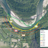
Alternative #4 involves digging a channel from the Skagit River into Barnaby Slough with the expectation that 30% of the river’s flow will pass through the slough back to the river. All the analysis performed thus far assumes a particular level of flow and the unimpeded movement of that flow through the slough back to the river. The analysis projects no increase in risk at a 100-year flood level. The analysis does not address any confounding circumstances, what might be called “worst case scenario” possibilities.
Our realistic concern is that a channel directing the Skagit River southwestward into a slough which has an elevation level exactly the same as the lands and homes located along Martin Road will present an increased exposure to flood risk that is impossible to mitigate. Let me say it this way. The valley floor here is like a table top and cutting a channel from the river into the Barnaby Slough is much like laying a fire hose down at an angle off the river. How much water would flow through the hose and what may happen to it cannot be known with certainty, nor can it be completely controlled.
It would be completely naive and foolish to assume that the model future will actually occur, that no more than 30% of the flow will move into the slough, that flood levels will not exceed the 100-year level in our uncertain climatological future, that no unforeseen environmental event will occur that would cause the entire River to suddenly shift into the channel, or even that the downstream exit from the slough and the river will behave as the project advocates optimistically anticipate. I’m sure our neighbors here in the Martin Road area can give you other risk possibilities that the plan does not address sufficiently.
Another analogy that’s occurred to me regarding the notion of cutting a channel from the Skagit is the design idea of drilling a hole in the hull of a boat. The mere creation of a hole in a boat hull creates a level of risk that cannot be fully mitigated. As any old salt will confirm, you never cut a hole in the hull of a boat that doesn’t need to be there. My challenge to the folks at the Skagit River Cooperative is to demonstrate how they will COMPLETELY MITIGATE any exposure to risk as a consequence of the channel they wish to construct, under any worst-case scenario. It’s not 1888. There are people living and working here immediately downstream of the Barnaby. Highway 530 exists.
At the recent public meeting conducted by the Skagit River Cooperative in Sedro Woolley, the consultant’s representative took pains to assert that the modeling and analysis do not represent reality. He acknowledged that the analysis is simply a projection based on certain assumptions and that the actual behavior of the environment cannot be predicted with any reasonable level of certainty. Let’s not let the thick, bound assortment of analytical data delude us into concluding that the future is clear.
So, I will ask again: What would happen if the Skagit River was blocked for some reason, causing more of the river to flow into the channel? What would happen if the downstream exit of the Barnaby was blocked? What would happen if there was a catastrophic Oso-slide like event that caused the river to shift considerably more of itself into the channel? What WILL happen when flood levels exceed the 100-year level? (At a recent Flood Plains By Design conference, it was noted that precipitation levels in our region are running at 125% of normal).
During the recent public meeting in Sedro Woolley, I asked Steve Hinton, the manager who is apparently responsible for this study project, if they had done any worst-case scenario analysis, and he replied that, yes, they had, and that the analysis indicated significant flooding on Martin Road. Then he confessed that they’d backed off from that analysis. Obviously, what they are publishing is intended to sell their project as essentially risk-free. Apparently, they are submitting a plan that conforms with a permitting requirement that they describe the consequences of their actions only in terms of the 100-year flood level. There is nothing in their plan stating how they will completely mitigate the exposure to risk of building the channel they’re envisioning. This disclosure leads me to question their integrity and the integrity of what they’ve published thus far.
To be frank, I see highly disturbing signs of hubris and one-sidedness in the conduct of the Skagit River Cooperative. Their eyes are narrowly focused on their fish habitat aims, to the exclusion of the well-being of land owners, farmers and residents living and working in our area along Martin Road. As they’ve conceded, their findings are less than forthright. Their plan thus far presumes that they will be able to control nature, when we all know that humanity’s capacity to do that is severely limited. In other words, the plan being developed lacks balance and integrity.
Many if not all of us here support fish habitat restoration as a valuable environmental, recreational and economic goal, but not at the risk of harm to our use and enjoyment of our lands and homes. We will appreciate your full support in assuring that anything done in our area relating to this project or any other fully respects our interests.


Leave a Comment
Your email address will not be published. Required fields are marked with *