Here is the finalized version of “Reach Assessment for SR 530 and 20 near the Skagit River Rockport Bridge,” produced by Rob Schanz, Hydrologist, of the Washington State Department of Transportation’s Environmental Services Hydrology Program.
What do you make of this report relative to the Barnaby project?
2015/09/sr530_skagitra_final.pdf
An immediate concern we may have about any report like this which is produced by a state agency is that it be independently created using the agency’s own findings of fact and analysis. As you read through this report, note the degree to which it relies on analysis produced for the SRSC in support of the SRSC’s effort to secure funding and regulatory approval of its project. A WSDOT technical report should not presume the factual validity of a purpose-driven study. That would be inappropriate on the part of WSDOT. Our Washington State Department of Transportation should conduct its own independent analysis and make its own independent judgment.
It is interesting that this “reach assessment” was posted on the SRSC’s Barnaby Project website, and I was referred to it there. It should be available directly from WSDOT. Mr. Schanz wrote in an email to me: “Note that we’ve provided the report to the Barnaby Slough restoration project team as background, but the purpose of the report is to help WSDOT assess erosion risks in the vicinity of the project under existing and proposed conditions. We are not advocating for or against the restoration project, but are stakeholders that the project team is working with because we have infrastructure in the vicinity.”
Well, it sure looks like WSDOT is at least a passive partner in the Barnaby Project.
Of course, WSDOT will be held accountable for its performance in serving the public interest, which with respect to the Barnaby project include consequent harm to our community of neighbors.
What do you see in this report that strikes you as significant?
Commentary in the report relative to the Barnaby project includes:
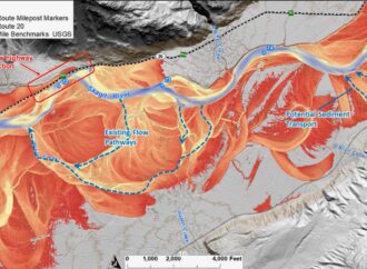
1) the observation that the Barnaby project, “…could substantially change river hydraulics and geomorphologic condition in this reach.”
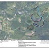
2) At milepost 99, “Risks at this location could occur if the river reoccupies this channel network, bringing the main energy of flow against the toe of the embankment along SR 20. The Barnaby Slough restoration project could increase the likelihood of this channel change.” (Page 8).
3) “Climate change is projected to alter the timing and magnitude of streamflows in the coming decades (Skagit River System Cooperative and Natural Systems Design, 2014). Warmer temperatures and changing storm patterns will likely result in more rain-dominated storms and less snow storage. This will increase winter peak flood flows and decrease summer flows.” (Page 12).
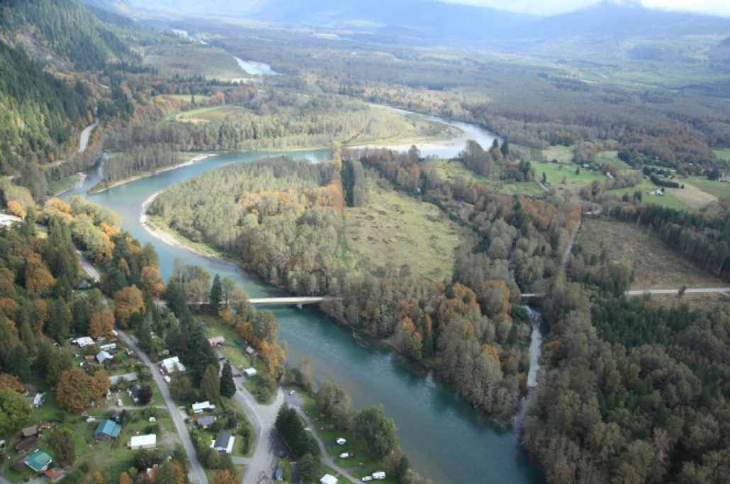
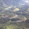
4) “The river is currently meandering along the northern margin of the valley, but meander scars and remnant oxbow lakes show extensive historical migration across the entire valley floor.” (Page 12).
5) “River banks within the alluvial floodplain are composed of more erodible sands and silts, and there are numerous relic channel features and meander scars that indicate frequent migration across the floodplain.” (Page 14).
6) “Between 1901 and 1944 the river abandoned Barnaby Slough, and now follows a straight and entrenched flow path from the upstream end of the project reach to the outlet of Barnaby Slough.” (Page 15).
7) “Flooding will continue to occur on low-lying portions of SR 530 approaching the bridges from the south, and on SR 20 east of MP 100.2. Climate change is likely to increase the frequency and extent of flooding.” (Page 20).
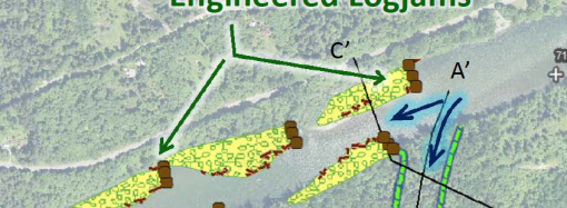
8) “Alternative 4 involves major in-river structures and channel modifications to actively direct more flow into Barnaby Slough and the southern floodplain. This alternative therefore has potential to change risks to portions of the WSDOT highway system. Areas.” (The SRSC has advanced the idea of cutting a channel from the Skagit River into Barnaby Slough, to divert a significant portion of river flow through the slough. This troubling notion is part of what the SRSC refers to as “Alternative #4.”)
Unfortunately, this report completely fails to address the consequences of good intentions gone awry. The diversion of part of the Skagit River into the Barnaby Slough creates the possibility of a major shift southwestward across the valley. The now relatively stable Skagit could make a massive move as a consequence of environmental changes and/or catastrophic events. This report perpetuates the hubris inherent in the SRSC’s design fantasy that Mother Nature’s behavior can be controlled and predicted. The Barnaby project needs to include careful consideration of negative possibilities to assure that whatever is done there to improve fish habitat has no negative effects on our safe enjoyment of our homes and lands.


Leave a Comment
Your email address will not be published. Required fields are marked with *